
Tjukayirla
Roadhouse
Fuel, Food and Accommodation on The Great Central Road
Tjukayirla Roadhouse – Local Attractions
The roadhouse takes its name from the Tjukayirla Rockholes, situated at the southwest end of the campground. Adjacent to the rockholes is the Paine and Barclay Surveyor marker which was placed by the surveyors in early 1930s during the original survey route to Warburton.
There is a large variety of wildlife in the area, at times dingos, emus, kangaroos and camels as well as a large variety of birds can be seen around the roadhouse.
A breakaway on the southern side of the Roadhouse is affectionately known as ‘The Zoo’, due to the animal faces take can be see in the shapes of the rocks, including an Elephant.
Empress Springs are located 60km north along the David Carnegie Rd, the junction of which is along the Great Central Rd 15km west of the roadhouse. The road is marked as 4WD only. The springs are inside a cave, access is via a chain ladder and there is a visitors book inside the cave.

More about Papulankutja (Blackstone) Community
Tjukayirla Roadhouse was built by the Papulankutja (Blackstone) Community, located on the northern side of the Blackstone Ranges (1200km from Kalgoorlie and 450km from Tjukayirla Roadhouse).
Papulankutja (more commonly referred to as Blackstone) Community is one of the founding communities of the Ngaanyatjarra Council. Incorporated in 1976, it is currently one of the larger communities on Ngaanyatjarra Lands and among the most beautiful and vibrant Aboriginal Communities in Australia. Blackstone Ranges region has an incredibly long and history as it continues to be one of the major population areas for Aboriginal people of the Central Reserve. Today it remains of great interest to anthropologies and archaeologists due to the preponderance of causal evidence of ancient peoples habitation – rock engravings and rock paintings, and old camping sites where grinding implements, stone flints and old camp-fire sites can be easily found in the region.

Ngaanyatjarra Lands
The Ngaanyatjarra Lands comprise a vast area of Western Australia (250,000 square kilometres) adjoining the Northern Territory and South Australian borders. The Ngaanyatjarra Lands are entirely within the state of Western Australia and fall within the Shire of Ngaanyatjarraku, the Shire of East Pilbara and the Shire of Laverton.
The Ngaanyatjarra Lands encompass sections of the Gibson Desert, Great Sandy Desert, Great Victoria Desert, and all of the Central Ranges within Western Australia. These immense areas of spectacular scenery have few obvious signs of human presence. The unique nature of the Ngaanyatjarra Lands, coupled with their remote location, precludes many land management activities that are practiced elsewhere in Australia. There has never been a pastoral industry and, apart from a few activities such as sandalwood harvesting, collection of dingo scalps and prospecting, there has been no other industry. The Ngaanyatjarra people have maintained a continuous association with their country and comprise the majority resident population.


Ngaanyatjarra Council
The Ngaanyatjarra Council is the principal organisation of governance in the Ngaanyatjarra Lands. The Council’s main objective is to provide support for the development of its members (in regard to health, education, housing, law and justice matters, finance and through a variety of commercial enterprises) and to achieve land rights for Ngaanyatjarra people. The Ngaanyatjarra Council’s administrative base is located in Alice Springs.
The Ngaanyatjarra communities operate as a cohesive and co-operative network under the umbrella of the Ngaanyatjarra Council. The Ngaanyatjarra Council endeavours to provide Ngaanyatjarra people remaining on their land with tools to ensure their lands are governed in a relevant and practical fashion that directly responds to their priorities and needs.
Outback Highway
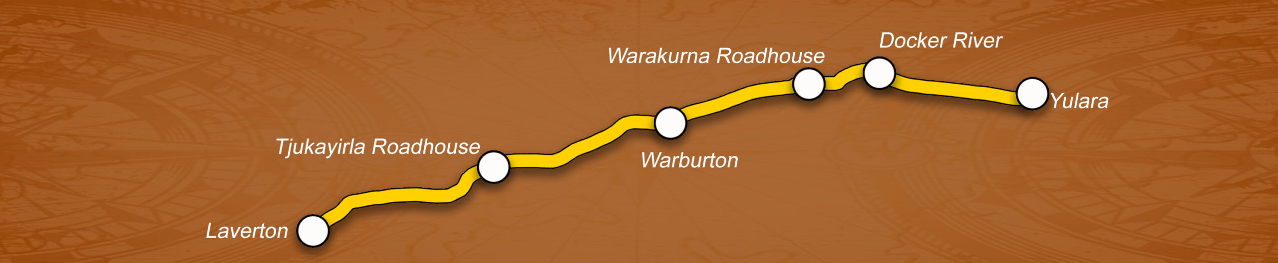
The Outback Way extends 2,800km from Laverton, Western Australia to Winton, Queensland via central Australia. As a self-drive route it passes through central Australia’s deserts, Ayers Rock, The Olga’s, Alice Springs and a host of fascinating places. The Outback Way is made up of seven inter-connecting roads including The Great Central Road (WA); Tjukaruru Road, Lasseter Highway, Stuart Highway and Plenty Highway (NT); and Donohue Highway and Min Min Byway (QLD).


The Great Central Road is the sole form of access to the Tjukayirla Roadhouse. It bisects the Ngaanyatjarra Lands east to southwest, providing access to those living on the lands to two major regional centres – Alice Springs (1,200 kilometres north east of Tjukayirla) and Kalgoorlie (650 kilometres south west of Tjukayirla). The 2,000 kilometre section of road from Laverton to Uluru National Park is unsealed and subject to wet weather closure.
The best time to travel the Outback Way is during the cooler months from April to October. The route passes through ten bioregions that are each characterised with a unique combination of flora, fauna, geology and landscape characteristics. The Outback Way is also home to The Outback Way-finder Geocache Trail, the World’s longest treasure hunt where a handheld GPS enables travellers to locate thirty four caches hidden at places of interest along the Outback Way. Tjukayirla Roadhouse has already featured prominently on the Geocache Trail and has welcomed a number of intrepid travellers responding to the recommendations of previous cachers.
The Outback Way offers travellers the opportunity to enjoy some of Australia’s icons as well as life in the outback, remote and rugged landscapes and an adventurous journey travelling across outback Australia. The Outback Way is all about the journey and enjoying the unspoilt wonders of Australia’s central deserts and remote outback. Tjukayirla Roadhouse is proud to feature as one of the premier stops along the way.
Trading Hours
Regular Trading Hours
- Monday to Friday - 9:00am to 5:00pm (WST)
- Saturday and Sunday - 9:00am to 3:00pm (WST)
- Public Holidays - 9:00am to 12:00 noon (WST)*
* Please note that none of the roadhouses across the Great Central Rd are open in the evenings. We advise checking the opening hours of each roadhouse prior to travel, especially if travelling on a public holiday.
Public Holiday Hours
- Good Friday 29/3/2024 – Closed – No After Hours
- Christmas Day – Closed – No After Hours
- New Years Day – Closed – No After Hours
- All Other Public Holidays 9am to Noon – No After Hours
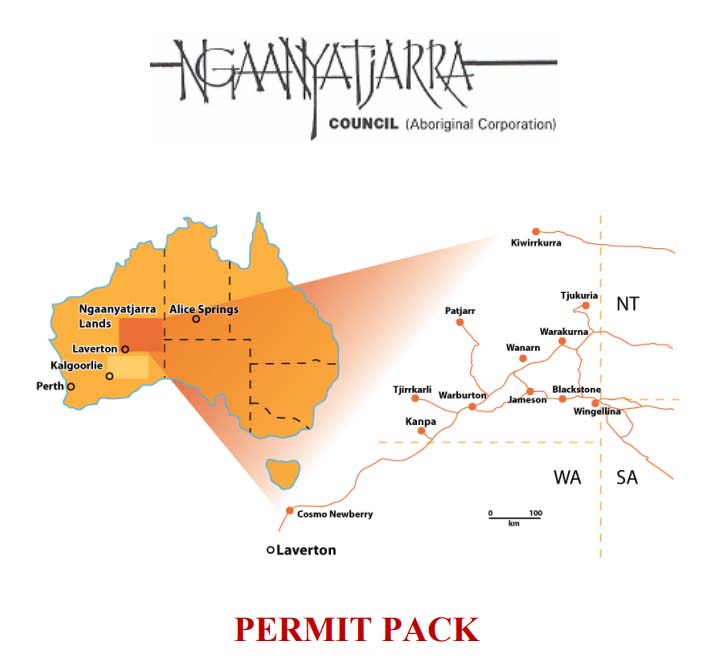
Permit Information
To enter the Ngaanyatjarra Lands visitors require an entry permit. It is also necessary to have a transit permit when travelling through the Lands by road.
The application process is simple and free. You can download a permit information and application pack (PDF format) by clicking on the image below.
Current Conditions
Information Updated : 02/10/2024
Road Conditions : Open both ways, Drive to conditions.
Weather Information : Overcast skies temps reaching mid 20's. Windy. 4mm of Rain overnight with more forecasted in the next two days.
Fuel Prices :
Diesel - $ 3.10 per litre
Opal* - $ 3.10 per litre
* Opal is replacement for unleaded petrol. Read more about Opal fuel by clicking here
Copyright © 2024 Tjukayirla Roadhouse | Designed and Hosted by Imageworkx.com